


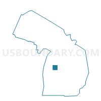
Voting District 0852480000004, Lake County, Michigan
About
Outline

Summary
| Unique Area Identifier | 597543 |
| Name | Voting District 0852480000004 |
| County | Lake County |
| State | Michigan |
| Area (square miles) | 36.50 |
| Land Area (square miles) | 36.44 |
| Water Area (square miles) | 0.06 |
| % of Land Area | 99.85 |
| % of Water Area | 0.15 |
| Latitude of the Internal Point | 44.12163880 |
| Longtitude of the Internal Point | -85.85626720 |
Maps

Graphs
Select a template below for downloading or customizing gragh for Voting District 0852480000004, Lake County, Michigan


Neighbors
Neighoring Voting District (by Name) Neighboring Voting District on the Map
- Voting District 0852526000005, Lake County, MI
- Voting District 0855748000008, Lake County, MI
- Voting District 0856312000010, Lake County, MI
- Voting District 0857168000015, Lake County, MI
- Voting District 1015790000001, Manistee County, MI
- Voting District 1657482000001, Wexford County, MI
Top 10 Neighboring County Subdivision (by Population) Neighboring County Subdivision on the Map
- Norman township, Manistee County, MI (1,553)
- Elk township, Lake County, MI (985)
- Newkirk township, Lake County, MI (632)
- Peacock township, Lake County, MI (492)
- Eden township, Lake County, MI (487)
- South Branch township, Wexford County, MI (383)
- Sauble township, Lake County, MI (333)
Top 10 Neighboring Unified School District (by Population) Neighboring Unified School District on the Map
- Cadillac Area Public Schools, MI (21,237)
- Baldwin Community Schools, MI (8,209)
- Pine River Area Schools, MI (7,662)
- Kaleva Norman Dickson School District, MI (5,626)
Top 10 Neighboring State Legislative District Lower Chamber (by Population) Neighboring State Legislative District Lower Chamber on the Map
- State House District 102, MI (99,061)
- State House District 101, MI (92,671)
- State House District 100, MI (86,569)
Top 10 Neighboring State Legislative District Upper Chamber (by Population) Neighboring State Legislative District Upper Chamber on the Map
Top 10 Neighboring 111th Congressional District (by Population) Neighboring 111th Congressional District on the Map
Top 10 Neighboring Census Tract (by Population) Neighboring Census Tract on the Map
- Census Tract 9613, Lake County, MI (2,838)
- Census Tract 3803, Wexford County, MI (2,813)
- Census Tract 9601, Lake County, MI (2,300)
- Census Tract 6, Manistee County, MI (1,641)